Its time to share some more results here, particularly as I’m excited to report that we’re about to embark on the first comprehensive landscape simulation study with iLand at the HJ Andrews Experimental Forest in the central western Cascades in Oregon. A brief digression: If you don’t know about the HJ Andrews (HJA in short) I’d highly recommend you check it out, it’s an amazing place, in terms of both the ecosystem and the group of people doing research there. We’re currently retracing the vegetation history for the 6400 ha HJA watershed with iLand, and below is an animation of a simulation for the two research watersheds 1 and 2. It’s one of the first runs that we did for larger portions of the HJA, but the results are quite encouraging, so here is what you see:
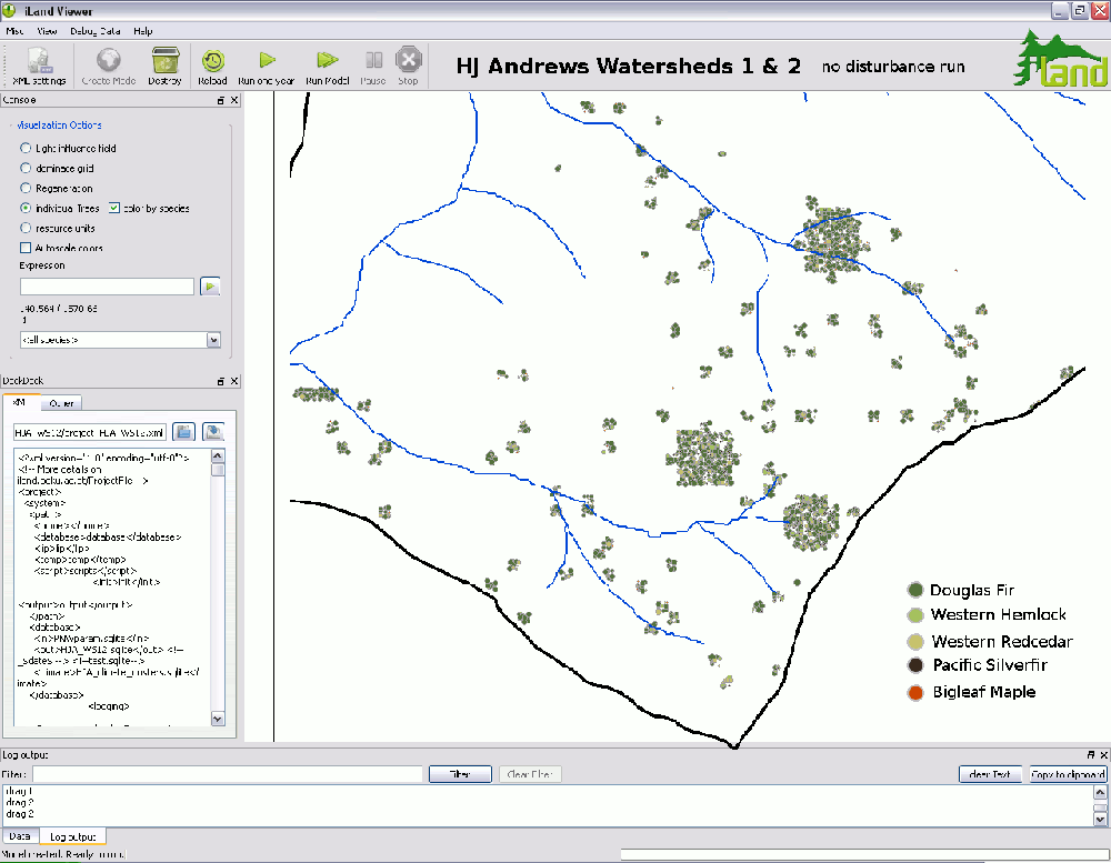
We know from extensive work on disturbance history, based on tree cores and fire scare dating, that about 500 years ago the landscape at HJA was hit heavily by stand-replacing disturbances. So we initialized the simulation with only a few remnants of patches representative of the pre-fire vegetation, while the rest of the 171 hectare watershed was assumed to be burnt over with high severity. In these patches, you can see that a high proportion is Douglas fir, i.e. the most fire-resistant species in the area. Douglas fir is also fastest in conquering the newly available growing space, and consequently the first 200 to 300 years are dominated by this species (the dark green in the simulation). However, towards the end of the 500 year model run (screenshots were taken in 5 year intervals for the animation above) the more shade-tolerant species like Western Hemlock and Western Redcedar are gaining ground, regenerating under the Douglas fir dominated canopy and slowly taking over. This can be seen particularly in the legacy patches, i.e. the areas that had survivor trees on them in the beginning of the simulation.
Another interesting thing that comes out in the model run is the environmental gradient in the two watersheds. As visibly by the stream patterns, the topographic gradient in the two watersheds goes from east (ridgetop) to west (valley bottom). The lower reaches are classified as Western Hemlock zone, while the upper reaches already belong to the cooler, wetter transition zone (transition to the montane true fir zone, that is). This gradient is also picked up by iLand, if you look at the occurrence of the occasional mature Pacific Silverfir. I.e. the dark dots appear only towards the eastern edge (i.e. the ridge) of the watershed and are completely absent in the lower reaches of the simulated area.
The last thing that I want to talk about today is environmental heterogeneity. Gaining a better understanding of spatial and temporal heterogeneity in environmental drivers is a main objective in developing iLand. And in this animation the effects of local variability in environmental factors (here rendered with a resolution of 100 x 100m) is quite apparent: The sites with deeper, richer soil, e.g. around the center of the simulated area, regenerate somewhat faster (only trees with a height >4m are drawn in the GUI, hence the explosive appearance of regeneration) than the surrounding areas, and the higher fertility of these sites remains visible long into the mature and old stages of forest development.
Well, I’ll stop here, but just from discussing the little animation above I guess you’ll get the idea of the exciting research questions that a framework like iLand enables us to look into.
Permalink: https://iland-model.org/blogpost25-Simulating-landscape-dynamics